We are sorry not to meet our friends at the 16mm
Peterborough AGM and Show. For the greater good, we are all staying at home. It
is a chance to read, dream and plan expeditions we can undertake once travel
restrictions are lifted. We start with a picture of the fascinating Péchot-Bourdon locomotive as it has several links with Lake Ohrid, links we discovered when researching our Péchot models and 'Colonel Péchot: Tracks To The Trenches'
 |
| Print of a Péchot-Bourdon locomotive, designed to run on portable track. Print courtesy Raymond Duton |
It is an area we long to visit. Ohrid and its sister lake Prespa are found in the Balkans peninsula, the
vast peninsula which separates the Adriatic from the Black
Sea. The Balkans are on the crossroads between Europe and Asia, so are generally interesting, but we’d like to
focus on the Ohrid area.
Ohrid appeals to my Scottish soul because it has affinities with
our own Loch Ness. The names of both lakes share the Scottish ‘huh’. Both lakes
act as boundaries. Loch Ness lies along an ancient fault-line separating the eastern and western Scottish highlands while Lake Ohrid
and Prespa are also in a
borderland. They separate the worlds of Mediterranean Europe and the lands to the
south. The lakes are survivors from a geotectonic depression which started
perhaps five million years ago. The corrugations – rugged mountains and deep
lakes of the Balkans - are the effect of the movement of vast tectonic plates
which apply unimaginable pressures on the surface of the land.
Lake Ohrid is Europe’s
oldest. How do we know that? Because of the variety of plants and animals which
are found nowhere else. At the risk of boring you with Lake Ohrid
facts, for its area, it is the most bio-diverse lake in the world. Species
evolve at a certain rate, so the theory goes – it a bit like estimating the age
of a hedgerow. So the unique waterweed and fishes are interesting in themselves but also
suggest that Ohrid has been there for a million years. The lake never silts up. Although sediment is
continually brought in by feeder streams, the restless earth sucks it away.
They call it subduction.
Unfortunately, our own Loch Ness is rather short on aquatic
life – too cold - so this method can’t be used to calculate its age but,
naturally, being a good Scot, I believe that Loch Ness too conceals its own
mysteries.
Lake
Ohrid is the deepest lake
of the Balkans. It is not the deepest lake in Europe
- that distinction belongs to Loch Ness. Almost as beautiful and strange are
the springs which constantly feed it. About 50% of its water comes in this way,
from an underground system which links Prespa to Ohrid.
This effect has a respectable scientific explanation; we are in karst country
where water dissolves away rock to find underground channels. It disappears only to reappear
miles away. From Celtic times, we Scots have found springs quite delightful, so
allow me my little moment of wonder.
 |
| Southern Balkans, centred on Salonika/Thessaloniki circa 1920. Ohrid and Prespa are just west of Bitola. Courtesy Times Publishing |
The water of lake
Ohrid has two exits. The
obvious one is the Black Drin River
which flows through Albania
to the Adriatic. There is another significant
one that is invisible. That is
evaporation, which channels no less than 40% of the water away.
The lakes deserve to be
better known – and the fact that they aren't, is a tragedy. They lie over the cultural and political
fissures which divide the Balkans. At present, the western shores of Ohrid are
Albanian, the eastern (roughly) in the Republic of Macedonia (Former Yugoslavia.
Lake Prespa
is divided between RoM,
Albania and Greece. Another block to them being better known is that they are also known as Ochrida and Presba.
This should not in itself be a problem. Lake
Geneva, aka Lac Leman, has French shores and Swiss shores.
Everyone gets along. People live on the French side and commute to the Swiss
side. Tourists can enjoy both. Alas, tourists can’t easily take a boat and sail
from one side of Ohrid to the other. Modern maps, so we are told, don’t even
show both sides of the lake, which seems to float off into a misty neverland as
you look from the shore.
 |
| Close-up of the area shows Presba/Presba and Ochrida/Ohrid. Salonika is to the south-east with Lake Lake Dojran due north of it. Snaking red national boundaries are very obvious. Courtesy Times Publishing |
Its human history goes back millennia. From nearby, pottery has been found that is over seven THOUSAND years old. The decorations are as fine as anything produced by a modern artist. Tourists should also be inspired by ‘To The Lake: A Balkan
Journey’ by Kapka Kassabova. As she puts it very kindly, history is still being
made here - ancient tensions have still not been resolved.
Our maps, courtesy of Times Publishing, show the lakes circa
1920.
Another reason to visit is that Ohrid played a pivotal role in the Péchot story. True to
character, it lay in a disputed no-man’s-land between the Allied Macedonian
Front and the Bulgarian sector of the Central Powers. In every Front, generals
attempted the breakthrough and on every Front, the usual result was stalemate. The
German Spring Offensives of March/April 1918 came the nearest to punching through the
British Front, but never quite succeded. After four years of war, the concept
of breakthrough had acquired a mythical status. The Russian Front, it was true,
had crumbled, but this was because of pressure from home rather than a knockout
military blow.
It was here, in the unpromising and rugged Balkan terrain, that the
stalemate was broken by the one true military breakthrough of the First World
War. Yet the battle of Monastir is hardly remembered because the place has
changed its name. Monastir has vanished from the map
(A bit of backstory) In 1915, the Bulgarians entered the War
on the side of the Central Powers. Their incentive was Serbian territory. The
Allies formed the Macedonian Front to oppose them. The British frontline,
somewhat unwisely, followed the valley of the Struma
river and its tributary the Strumitza. Their main enemies were mosquitoes
carrying malaria which caused many more casualties than the Bulgarians. The French and Serbs were to their west, on a Front running
from from Lake Dohran/Dojran to Prespa and Ohrid. It was, to
put it mildly, rough ground. But there were no mosquitoes and the Serbs were
almost in home territory. One big disadvantage was the lack of transport. There
were few railways anyway and the north-south links had been cut by the
Bulgarians.
 |
| Various designs of portable prefabricated track were used by both sides in the first world war. If they could, they used captured material, as these jumbled tracks suggest. Photo Malcolm Wright |
In 1916, the
Serbian-French were fighting south of the little railway town of Florina, in the valley of the Echisu/Ekhisu, in the southern
headwaters of the Varna
river. Over the next couple of years they pushed their way north along the
track of the railway towards Monastir (modern Bitola) to the south of Ohrid. How did they
transport the big guns, and more importantly, the ammunition?
The traditional way was by mule, 70kg per mule, quite
inadequate for modern warfare. The iron road had to return; a 60cm portable
railway with its freight-carrying capacity. General Franchet d’Esperey, field
commander, asked for daily reports on progress of the line down the Ekhisu
valley, so highly did he esteem the value of 60cm. The final assault on Monastir/Bitola
could not take place until 60cm was in place. By September 15th
1918, all was ready.
The battle for Monastir/Bitola was savage, involving trains,
guns, planes and old-fashioned cavalry charges. The breakthrough happened in
the Cerna river valley. By September 20th, the hole in the Bulgarian defences was 25
km deep, by the 25th, well over 50 km. At the most northerly point of the
breakthrough, Serbs were entering Istip (Ishtip). It was a classic
breakthrough, the attackers making their way through the weak point and fanning
outwards. The map is like a refractive pattern, waves making their way through a weak point
in a barrier and then spreading out.
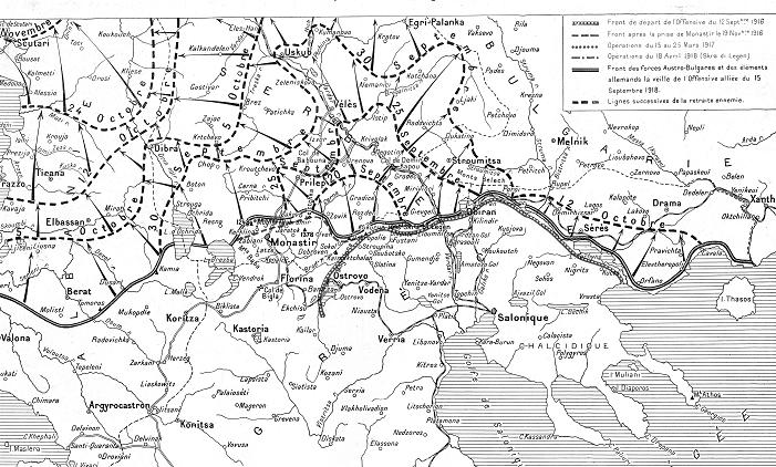 |
| The Balkan Front (double line) 15thSeptember 1918, centred on Monastir/Bitola, Ohrid and Prespa lying to the west.The broken lines show the stages of the breakthrough, successively 20th, 25th, 30th September and then 5th and 12th October. Illustration magazine Courtesy Malcolm Wright |
The northern shore
of Lake Ohrid was not
taken until September 30th. By then the Bulgarian Government had
agreed an Armistice with the French, valid from midnight. At this point, the
British troops roused themselves and started thrashing the Bulgarians. Given
the situation, this was not quite cricket.
After the Bulgarian Armistice, it was only a matter of time
before the collapse of the other Central Powers. In the words of Prosper
Péchot’s proud son, all could be credited to his father’s railway inventions.
Once the War was over, all the track and rolling stock were safely gathered
into French military depots,
This area reappears in the Péchot story. During the Second
World War, the Nazis confiscated all the French military material. Most was
scrapped including almost all Péchot-Bourdon locomotives. Two survived the War, one
being relocated to the Dresden area in what was
then the DDR and one came to Pozega in what is now Serbia. This precious survivor spent more than 60 years a few kilometres north of Ohrid. This Serbian Péchot-Bourdon is in France for
restoration – a treasure of history.
 |
| Rough country! After the breakthrough, French colonial troops take a Bulgarian position. Illustration magazine. Picture courtesy Malcolm Wright |
No comments:
Post a Comment